Video for this Hiking!!
I went hiking to Mt. Dana in Yosemite National Park this
weekend. Originally, I would go there
last weekend, however I thought it might be very crowded last weekend due to
July 4th weekend. So I went
Lassen Peak instead.
Mt. Dana
Mt. Dana is the second highest mountain in Yosemite National
Park. It is 13,061 feet (3,981m)
elevation. In major map I checked, there
is no trail to the mountain. However,
if I search some information on the internet, many people hiked there and they
indicate there is a trail from Tioga pass entrance. However, the trail is not very clear especially
right below the summit. Anyway, it
seemed that the view from the summit was really beautiful on many photos posted
on the internet.
Approach
Tioga pass was on the way to Lone Pine to hike Mt. Whitney
two weeks ago. So I took the same way
to there, taking I-580 ~ I-5, ~ CA-120/108.
It took about 4-hour drive from my home. I left my home about 4am in the morning and
arrive there around 7:30am. There is no
other cars in the parking lot next to Tioga pass entrance. I know Yosemite NP is really popular place in
summer and all parking lot could be full late in the morning. So, I tried to arrive there early.
Trail

GPS tracking data for this hiking on a map
A parking lot right
next the entrance, there is a sign which says “authorize vehicle only”, and
therefore I parked my car on the north side.
There is a restroom next to the parking lot. From the parking lot, just crossing CA-120
and pass the entrance station, there is a clear trail toward south. There are a several lakes near trail and they
are really beautiful lakes. I saw nice
cloud and blue sky on the surface of lakes.
Around Tioga pass, there is wetlands with lakes and many wild flowers
and the trail is going through the wetlands in the beginning.

A lake next to this trail
After a several
minutes walking, the trail is getting steeper and starting switch back to get
elevation gain. From the trial, I saw many
beautiful mountains on west to north side with snow. Above the tree line, the slope is getting
steeper and it is not usual for many trails in the United States. Like Mt. Whitney Trail, it is designed not
to have steep section. This trail is
obviously steeper than Mt. Whitney Trail.

Mountains on the west side from the trail
About 1 hour
walking, I got into a plateau and the slop was getting a bit gentle, however,
the wind was getting cold. I wear a
jacket and globes. On the last slope,
it was getting steep again and the trail is not very clear. It seemed there were probably at least 2
trails toward the top. I was not sure
which trail would be a better one.
However, it could go up anywhere.
So I thought it was not a big deal.
I took the left trail, but it was not very clear all the way. So I just toward the top and just walked
up. It was not too bad.

Wild flower
The summit was
really windy and cold. I just took some
photos and video. On the east side, I
saw entire Mono Lake. Then, I saw many
mountains from south ~ west ~ north.
Many mountains still had snow and they are so beautiful. Since it was cold, I started going down
without resting on the summit.
Descending is easy and I just took 1 and half hour.
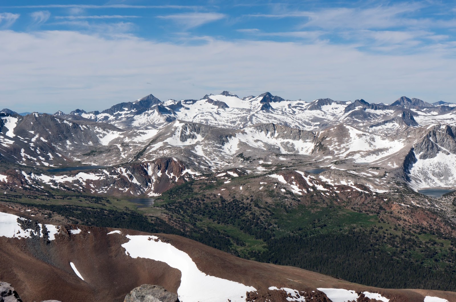
View from the summit

Mono Lake from the summit
Notes
I think it is
better to start early. The parking was
getting crowded when I came back to the parking lot. There was no parking space any more. However, there were a few spaces in another
parking lot. Early in the morning,
there were some clouds, but they were going away around noon time. However, after that, I do see cumulonimbus on
the sky when I drove back. So there
might be a chance of lightning. I guess
it would be better to start early and be back early in the afternoon.
There were a few location
where we need to across small snow.
However, they were not a big deal.
It was really easy to across the snow.
The trail is not
very clear right below the summit.
However, we can climb anywhere.
So people just need to toward the top.
Only thing is just to be careful the east side is really steep. Probably, trail on the right side (west
side) would be a little clear in my opinion.
The altitude
sickness, I did not have any symptom at all.
The big problem was that I forgot to wear heart rate monitor this time
and I did not have a very good data.
But I did manage my pace very well based on the past 2 weeks for the
other hiking. I can manage my pace
without heart rate value. The pace was
slowing down a little, but I believe this was due to steeper slope. I guess my heart rate was less than 155bpm
this hiking

Elevation and walking speed
|
|
Time
|
Distance (km)
|
||
|
Tioga Pass
|
0:00
|
--
|
0
|
--
|
|
Plateau
|
1:20
|
1:20
|
3.0
|
3.0
|
|
Summit
|
2:20
|
1:00
|
4.5
|
1.5
|
|
Tioga Pass
|
4:05
|
1.45
|
9.5
|
5.0
|
This is a short trail, but I really recommend this
trail. I guess people may try a season
with some snow like this time, something around late June to July.
Video for this Hiking!
No comments:
Post a Comment